|
AREA AND POPULATION |
|||
|
Sl. No. |
Description |
Particulars |
|
|
1. |
Annual Rainfall |
1,347 mm |
|
|
2. |
Population |
48,35,532 Nos. |
|
|
3. |
Density of Population |
890 Nos. |
|
|
4. |
Sex ratio : |
Male |
51.07 % |
|
Female |
48.93 % |
||
|
5. |
Population Ratio: |
Rural |
84.98 % |
|
Urban |
15.02 % |
||
|
6. |
Workers |
40.36 % |
|
|
7. |
Non-Workers |
59.64 % |
|
Medical Facilities
|
Sl. No. |
Description |
Particulars |
|
1. |
Hospitals |
3 Nos. |
|
2. |
Rural Hospitals |
5 Nos. |
|
3. |
Block Primary Health Centres |
19 Nos. |
|
4. |
Primary Health Centres |
74 Nos. |
|
5. |
Total no. of Bed |
4,360 Nos. |
Road Length
|
Sl. No. |
Description |
Particulars |
|
1. |
Surfaced |
8,228.76 K.M. |
|
2. |
Un-Surfaced |
3704.83 K.M. |
|
3. |
Number of registered Motor Vehicle |
907117 Nos. |
Education
|
Sl. No. |
Description |
Particulars |
|
|
1. |
Literates : |
Male |
81.27 % |
|
Felame |
69.43 % |
||
|
Total |
75.48 % |
||
|
2. |
Primary : |
Institution |
3,008 Nos. |
|
Student |
2,49,491 Nos. |
||
|
Teacher |
9,487 Nos. |
||
|
3. |
Middle : |
Institution |
127 Nos. |
|
Student |
9,778 Nos. |
||
|
Teacher |
397 Nos. |
||
|
4. |
High : |
Institution |
373 Nos. |
|
Student |
2,34,329 Nos. |
||
|
Teacher |
5,867 Nos. |
||
|
5. |
Higher Secondary : |
Institution |
245 Nos. |
|
Student |
2,66,610 Nos. |
||
|
Teacher |
4,569 Nos. |
||
|
6. |
Colleges/ University : |
Institution |
20 Nos. |
|
Student |
51,692 Nos. |
||
|
Teacher |
1,011 Nos. |
||
|
7. |
Professional & Technical School & Colleges |
Institution |
60 Nos. |
|
Student |
11,588 Nos. |
||
|
Teacher |
1,029 Nos. |
||
|
8. |
Special & Non-formal Education |
Institution |
7,571 Nos. |
|
Student |
2,77,766 Nos. |
||
|
Teacher |
9,466 Nos. |
||
|
9. |
Public Library |
151 Nos. |
|
|
10. |
Mass Literacy Centre |
7,862 Nos. |
|
District Website (Purba Bardhaman)
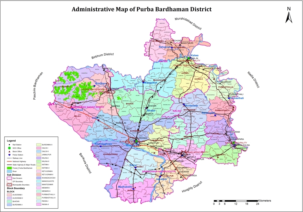
DISTRICT POLITICAL MAP DISTRICT STATISTICS
TERRAIN OF THE DISTRICT
|
East |
Longitude |
87o 27’ 9.521”E |
|
Latitude |
23o 28’ 52.063”N |
|
|
West |
Longitude |
88o 25’ 15.183”E |
|
Latitude |
23o 12’ 45.047”N |
|
|
North |
Longitude |
87o 59’ 39.005”E |
|
Latitude |
23o 50’ 28.432”N |
|
|
South |
Longitude |
87o 50’ 42.352”E |
|
Latitude |
22o 56’ 53.233”N |
|
East |
Nadia District |
|
West |
Paschim Bardhaman District |
|
North |
Murshidabad & Birbhum District |
|
South |
Hooghly & Bankura District |
|
GENERAL PROFILE |
|
|
State |
West Bengal |
|
District |
Purba Bardhaman |
|
Area (in Square KM) |
5432.69 |
|
Total Polling Stations |
4407 |
|
Total Parliamentary Constituencies |
2 |
|
Total Assembly Constituencies |
16 |
|
Total ST Population(in %) |
6.41 |
|
Total Population Density(per Sq. KM) |
1269 |
|
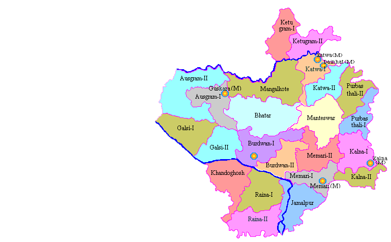
No. of Sub-Divisions |
4 |
|
No. of Blocks |
23 |
|
No. of Gram Panchayats |
215 |
|
No. of Census Village |
2215 |
|
No. of Municipal Corporation |
0 |
|
No. of Municipalities |
6 |
|
No. of Town/Notified Area |
0 |
|
No. of Post Offices |
3230 |
|
Total Road Length(in Km) |
4699 |
|
National Highway Length(in Km) |
86 |
|
State Highway Length(in Km) |
173 |
|
District Road Length(in Km) |
584 |
burdwanzp.org © Purba Bardhaman Zilla Parishad. 2014-2026Disclaimer
Website Design and Developed by Sabmecto